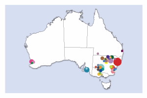
| Feather Collection MapNow in it's final year, the Feather Map of Australia project has received an overwhelming response from members of the public collecting and submitting feathers from over 439 wetlands around Australia as shown in the latest interactive map of collection points to date. These feathers will be used to track the movement of waterbirds around Australia from wetland to wetland based on an analysis of feathers to identify stable isotopes and mineral elements.With the project wrapping up at the end of next month, project leaders are calling on citizen scientists to get involved one last time, collecting and submitting their wetland feathers for analysis by no later than Friday 29 June, with results to be released shortly after.Thank you to those that have shown an interest in the project and have participated in helping to preserve our precious wetland birds and their habitats. This research would not be possible without you.
Published: 21 May 2018 |
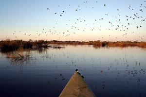
| NSW flooding triggers mass waterbird breeding event at Macquarie MarshesTens of thousands of waterbirds have flocked to internationally recognised wetlands in the NSW far west, as floodwaters fill marshes for the first time in four years. The Macquarie Marshes north-west of Dubbo is thought to be the most important site in Australia for colony-breeding waterbirds such as the ibis, egret and heron. Director of the Centre for Ecosystem Science at the University of New South Wales and Feather Map researcher, Professor Richard Kingsford, said environmental flows along the Macquarie River had triggered an essential breeding opportunity after four dry years. More Published: 26 October 2016 |
 | Celebrate National Bird WeekIt’s National Bird Week, so what better time to get involved in the Feather Map of Australia Project! We’ve already received thousands of feathers from close to 200 wetlands from across the country. Although this is a fantastic effort, we still need many more to create our Feather Map. You can view locations we’ve received feathers from so far here. Participation is open to everyone and it’s simple. All you need to do is collect wetland bird feathers you find on the ground or in the water and mail them in. Once received, researchers from the Australian Nuclear Science and Technology Organisation and the University of New South Wales analyse the feathers using nuclear techniques to track the movement of waterbirds, creating the first ever Feather Map of Australia. This resulting information can be used by water and wetland managers to inform decision making and help researchers better understanding waterbirds to ensure their survival. Learn more at Get Involved Published: 17 October 2016 |
 | Bruny Island Bird Festival 2016Held from the 14 to 17 October in Tasmania, the 2016 Bruny Island Bird Festival is a celebration of Bruny's beautiful birds, habitats and landscapes featuring a huge range of events for children and families. Take part in bird watching tours and walks, listen to talks by bird experts and get involved in some creative arts fun. For the full program click here.
Published: 4 October 2016 |
 | Get wild about wetlandsGet wild about wetlands these October school holidays at Cockburn Wetlands education centre with a range of fun activities suitable for kids aged 5-12 years.
Published: 22 September 2016 |
 | Feather Map researcher Patricia Gadd wins 'On the Job' competitionThe Australian Academy of Science announced today that Feather Map researcher and ITRAX Facility Officer Patricia Gadd is the national winner of the 'On the Job' competition. The ITRAX Facility is used to anaylse feathers sent in by citizen scientists as part of the Feather Map of Australia Project. Patricia was one of seven finalists chosen from across Australia, who keep Australian science moving. Matt Bell from the Australian Centre for Neutron Scattering at ANSTO was also a finalist and featured in a short video produced by Australia's science channel, shared during National Science Week.Patricia was the people's choice for the award as it followed a public vote during National Science Week. The competition recognised Australia's laboratory and field technicians, support staff and machine operators who keep Australian science moving ahead. Read More Published: 29 August 2016
|
 | Become a citizen scientist todayWe’ve already received hundreds of feathers from around the country but we still need many more to enable our researchers to use nuclear techniques to help wetland birds and their precious habitats. If you live or are visiting a wetland location not indicated on the map get involved and become a citizen scientist today. We look forward to receiving your feathers. Read More Published: 25 August 2016 |
 | Nuclear physics uses single feather to track and help save Australian waterbirdsScientists are using nuclear physics to track and potentially save Australia's declining waterbird numbers — and they are doing it with discarded feathers. The team of researchers are using a new method developed at the Australian Nuclear Science and Technology Organisation (ANSTO) to work out where a bird has been and what it has eaten using the chemical composition of the feathers. The analysis is providing crucial information to help governments plan to protect wetlands and the declining number of birds that inhabit them. Read More Published: 15 August 2016 |
| Life in the ParkCome and join a free series of short talks by special guests on urban wildlife; including Feather Map researcher Dr Debashish Mazumder. Learn about local native animals and how to protect their habitats. Enjoy frog and bird displays, fun kids' activities plus live footage of nesting White-bellied Sea- Eagles. When: 28 August 2016 Published: 14 July 2016 |
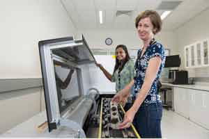
| The Feather Map of Australia is a citizen science project plotting the movements of our country's wetland birdsResearchers are asking members of the public to collect and send in waterbird feathers to be analysed, in order to collect crucial information about the nutritional ecology and habitats of birds. Feathers collected by citizen scientists will be analysed using special nuclear science techniques, such as mass spectrometry and high resolution X-ray fluorescence. The Project, run by the Australian Nuclear Science and Technology Organisation and the University of New South Wales, is an Australian-first and provides a new, non-invasive method for tracking waterbirds without the need for their capture. Read More Published: 22 June 2016 |
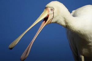
Australia’s waterbirds are disappearing – but nuclear physics can help save themWhen wetlands flood they become full of life. They are spectacularly beautiful and noisy.There is nothing quite like the sound of a wetland when thousands of birds come together to take advantage of the newly created habitat. Ibis, spoonbills, egrets, herons, cormorants and pelicans all congregate in large numbers, tens to hundreds of thousands, to breed when wetland conditions are good. These gatherings of birds are spectacular, but a mystery remains: where do they come from, and where do they go? Read more Published: 15 April 2016 | |
| Researchers Launch ‘Feather Map Project' To Monitor Threatened Waterbirds And WetlandsNever before have a string of bird feathers held such promise. A group of researchers and nuclear scientists have launched a project that aims to track the movements and health of wetland birds across Australia by collecting their feathers. And they are enlisting the help of the general public. “We are aiming to improve how we manage the conservation of both wetlands and waterbird populations,” project leader and environmental researcher Dr Kate Brandis told The Huffington Post Australia. Read More Published: 8 April 2016 |
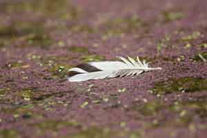 | Mapping Australian wetlands, feather by featherNext time you find yourself in a wetland keep your eyes peeled for stray waterbird feathers. A new citizen science program – the Feather Map of Australia – is asking people of all ages to collect and post in feathers they find for analysis. Using equipment similar to an x-ray machine, the scanned feathers will help identify the bird species and reveal information about its diet, where it's been and how healthy its habitat is. Ultimately, it will create a map of waterbird populations around Australia. "The aim is to improve our conservation of both wetlands and waterbird populations [which are] being hit pretty hard at the moment," says Dr Kate Brandis, leading the joint project between the University of NSW and the Australian Nuclear Science and Technology Organisation (ANSTO). Read more Published: 31 March 2016 |
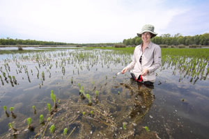 | Creating a Feather Map to track waterbirds and inform water resource managementANSTO and the University of NSW, Australia (UNSW) have launched an initiative with a citizen scientist component that will enable tracking of the movements of waterbirds between regional wetland sites across Australia. “There are some big questions about waterbird movements,” said project leader Dr Kate Brandis (pictured left), an environmental researcher at ANSTO and UNSW who is an expert on colonially breeding waterbirds. “Colonial birds come together in their thousands on flooded inland water systems to breed. Then they disappear into much smaller groups. And then you might not see them for years. We would like to determine where they go and where they come from when they come back,” explained Brandis. Read more Published: 22 March 2016 |


_ACS087980_171894_Native File.png)
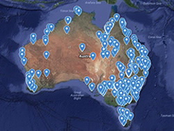
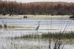 Image Credit: Office of Environment and Heritage
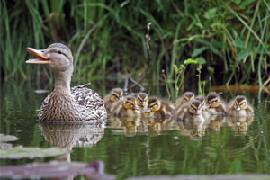
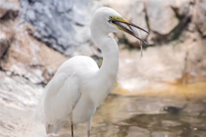 Image Credit: Joshua Praveen
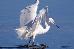
 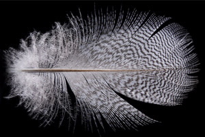 Image credit: Nick Cubbin